|
Many people
believe that Saudi Arabia physiographic features are only great sand seas and
might not associate it with volcanic activities.
In fact, vast volcanic fields,
known in Arabic as the harrat,
emerged during the Cenozoic Era as a consequence of the rifting and drifting
of
the Arabian plate away from the African plate which led to the formation of the
Red Sea and the volcanically active passive continental
margin on western
Arabia (Figure 1). Volcanic activity spanned over a large period from the
Oligocene (30 Ma) to historical times.
In Saudi Arabia, the volcanic fields extend
from its northern borders with the Levant to its southern borders with Yemen.
There are 13
distinct volcanic fields in western Saudi Arabia that cover an approximate
area of 89,670 km2 with an estimated total volume of eruptive
material of about 103 to 105 km3 (Table 1). Fortunately, most of the
volcanoes are extinct; very few had erupted more than 1,000 years
ago and only
one erupted in AD 1256.
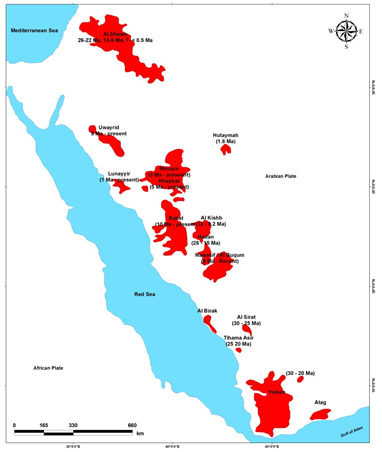
Table (1): Cenozoic Volcanic Fields in Western Saudi Arabia
|
Harrat
|
Area (km2)
|
|
Khaybar-Ithnayn-Kura
|
21,400
|
|
Rahat
|
18,100
|
|
Al-Harrah
|
15,200
|
|
Nawasif-Buqum
|
10,800
|
|
Rahat-Uwayrid
|
7,150
|
|
Kishb
|
6,700
|
|
Hadan
|
3,700
|
|
Al-Birk
|
1,800
|
|
Lunayyir
|
1,750
|
|
Kurama
|
1,100
|
|
Hutaymah
|
900
|
|
As Sirat
|
750
|
|
Jabal Jilan
|
320
|
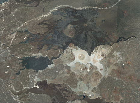
Harrat Khaybar is considered as one of the most spectacular volcanic fields in Saudi Arabia (Figure 2). Its landscape is dominated by
Jabal Qidr, which is a hawaiite stratovolcano believed to have erupted in historic times. The dark lava field of Jabal Qidr juxtaposes the
white comenditic ash and lapilli plains of the nearby White Mountains of Jabal Abyad and Jabal Bayda.

The
significance of Harrat Rahat emerges from the fact that its northern fringes,
where the historical eruption of the AD 1256 took place,
are very close to Al-Madinah
Al-Munawarah (Figure 3). The eruption, which lasted for 52 days, extruded 0.5
km3 of alkali-olivine
basalt from a 2.25 km-long fissure and
produced 7 scoria cones and a 23 km long
lava flow that came to within 8 km from
Al-Madinah Al-Munawarah (Figure 4).
Between April and June 2009,
a swarm of more than 30,000 earthquakes struck the lava field of Harrat
Lunayyir in northwestern
Saudi Arabia (Figure 5). During the peak activity on
May 19, 2009, nineteen earthquakes of
M4.0 or greater struck the region, including
an M 5.4 event, which caused minor
damages to structures in the town of Al Ays (40 km southeast of the epicenter).
Concurrently,
a northwest-trending 8-km-long surface rupture with 91 cm of
offset propagated across the northern part of the volcanic field (Figure 6).


The ensuing geologic and geodetic studies
suggested that the earthquake swarm resulted from a shallow magmatic intrusion
of a
north-west trending dyke of about 12
km in length and a maximum thickness of 2.5 meters where two normal faults
bound a
wedge-shaped graben above the
arrested dyke. One of the most recent
studies, however, suggests that both dyke
emplacement and
normal faulting were partly triggered by a regional extensional
loading. The study also inferred that the
dyke tip became arrested at
a depth of
only a few hundred meters concluding that the dyke, on its own, could not have generated the entire 3–7 km wide
fracture
zone associated with the 2009 episode. The same study estimated the
thickness of the dyke at shallow depths
as being in the
range of 6–12 m with inferred strike dimension (length) of 14
km and dip dimension (or depth) in the excess of 20 km.
References:
Al Shehri, A. and Gudmundsson, A., 2018. Modelling of surface stresses and fracturing during dyke emplacement: Application to the
2009 episode at Harrat
Lunayyir, Saudi Arabia. Journal of Volcanology and Geothermal Research, 356,
278–303.
Baer, G. and Hamiel, Y., 2010. Form and growth of an embryonic
continental rift: InSAR observations and modelling
of the 2009
western Arabia rifting episode. Geophysical Journal International,
182, 155-167.
Camp, V.E. and Roobol, M.J., 1989. The Arabian continental alkali
basalt province: Part I. Evolution of Harrat Rahat, Kingdom of
Saudi Arabia.
Geological Society of America Bulletin, Vol. 101, pp. 71-95.
Camp, V.E., Hooper, P.R. Roobol, M.J., and White, D.L., 1987. The
Madinah eruption, Saudi Arabia: Magma mixing and
simultaneous extrusion of
three basaltic chemical types. Bulletin of Volcanology, Vol. 49, pp. 489-508.
Camp, V.E., Roobol, M.J., and Hooper, P.R., 1991. The Arabian
continental alkali basalt province: Part II. Evolution of Harrats Khaybar,
Ithnayn, and Kura, Kingdom of
Saudi Arabia. Geological Society of America Bulletin, Vol. 103, pp. 363–391.
Coleman, R.G., Gregory, R.T., and Brown, G.F., 1983. Cenozoic
volcanic rocks in Saudi Arabia. Ministry of Petroleum and
Mineral Resources,
Deputy Ministry for Mineral Resources, Jeddah, Kingdom of Saudi Arabia, Open-File Report, 83-788.
Moufti, M.R. and Nemeth, K., 2014. The White Mountains of Harrat
Khaybar, Kingdom of Saudi Arabia. International Journal of
Earth Sciences
(Geol. Rundsch.), 103, 6, 1641–1643.
Moufti, M.R., Németh, K., Murcia, H., Lindsay, J.M., and El-Masry,
N., 2013. Geosite of a steep lava spatter cone of the 1256 AD,
Al Madinah
eruption, Kingdom of Saudi Arabia. Central European Journal of Geosciences, 5,
2, 189-195.
Pallister, J.S., McCausland, W.A., Jónsson, S., Lu, Z., Zharan,
H.M., El Hadidy, S., Aburukbah, A., Stewart, I.C.F., Lundgren,
P.R., White,
R.A., and Moufti, M.R.H., 2010. Broad accommodation of rift-related extension
recorded by dyke intrusion in
Saudi
Arabia. Nature Geoscience, DOI: 10.1038/NGEO966, 8 pp.
Online Sources:
1.
http://www.sgs.org.sa/English/Earthquakes/Pages/Volcanoes.aspx
2.
http://www.volcano.si.edu/volcano.cfm?vn=231040
3.
http://traversingtherazor.wordpress.com/2010/10/20/earthquakes-and-volcanoes-in-saudi-arabia/
4.
https://www.google.com/search?q=harrat+saudi+arabia&rlz=1T4GPCK_enUS344US345&tbm=isch&tbo=u&source=univ&sa=X&ei=IFyPU_nHBaLMsQT0pYD4Ag&ved=0CG0QsAQ&biw=1413&bih=730
5.
https://zoom.earth/#25.670598,39.943024,13z,sat
6.
https://zoom.earth/#24.439154,39.681185,12z,sat
7. https://zoom.earth/#25.130341,37.845871,11z,sat
|